
Squaw Ridge/Pardoe trail/ NorCal
 Jan 15, 2010 | 11:20 AM
#103
Thread Starter
Registered User
Joined: Oct 2008
Posts: 1,621
Likes: 7
From: Sacramento, Crawlifonia
http://www.filefront.com/15360375/squaw-ridge.kmz/
the link above will take you too where you can download the file.
you must have google earth to use this file. to get google earth click on the link below.
http://earth.google.com/#utm_campaig...utm_term=earth
once you have the dl (download) and google earth installed. double click on the dl file and google earth will open. on the left hand side of google earth you will see a cascading tree menu. scroll down that menu and look for squaw ridge. double click squaw ridge and a squaw ridge listing will open, it has three little red dots next to it. double click on the new listing with the three little red dots.
now you should see the trail marked out in red. have fun.
if you have any questions let me know

 haha I have an idea of what I want.
Jan 16, 2010 | 08:11 PM
haha I have an idea of what I want.
Jan 16, 2010 | 08:11 PM
#106
Thread Starter
Registered User
Joined: Oct 2008
Posts: 1,621
Likes: 7
From: Sacramento, Crawlifonia
Jan 17, 2010 | 08:13 PM
#107
Registered User
Joined: Mar 2009
Posts: 794
Likes: 0
From: Vina, Ca.
hahaha yeah i am gonna owe the fed like $100 lol so no tax return for me. effing unemployment.
SOOO anyways I just got back from my trip to yosemite. what a great trip we had a LOT of fun. We stayed in Mariposa went through the park saturday. I needed 3 more days for photography but oh well. My cuz and her husband took us shooting this morning. it was pretty cool (and cold). what was really cool though was that when we stopped I was looking straight at Signal Peak. My cousin's hubby works for NPS Fire and is going to try to get me out there in the spring on roads most never get to see. I am stoked. will post a pic later of signal peak. I am beat from the drive home.
Anyways tomorrow probably starts the tear down of the axels tomorrow. got some play in the front left tire. new bearings and some other new stuff is needed. then for the pitman and idler replacment.
 Jan 18, 2010 | 06:37 PM
#109
Thread Starter
Registered User
Joined: Oct 2008
Posts: 1,621
Likes: 7
From: Sacramento, Crawlifonia
hahaha yeah i am gonna owe the fed like $100 lol so no tax return for me. effing unemployment.
SOOO anyways I just got back from my trip to yosemite. what a great trip we had a LOT of fun. We stayed in Mariposa went through the park saturday. I needed 3 more days for photography but oh well. My cuz and her husband took us shooting this morning. it was pretty cool (and cold). what was really cool though was that when we stopped I was looking straight at Signal Peak. My cousin's hubby works for NPS Fire and is going to try to get me out there in the spring on roads most never get to see. I am stoked. will post a pic later of signal peak. I am beat from the drive home.
Anyways tomorrow probably starts the tear down of the axels tomorrow. got some play in the front left tire. new bearings and some other new stuff is needed. then for the pitman and idler replacment.
SOOO anyways I just got back from my trip to yosemite. what a great trip we had a LOT of fun. We stayed in Mariposa went through the park saturday. I needed 3 more days for photography but oh well. My cuz and her husband took us shooting this morning. it was pretty cool (and cold). what was really cool though was that when we stopped I was looking straight at Signal Peak. My cousin's hubby works for NPS Fire and is going to try to get me out there in the spring on roads most never get to see. I am stoked. will post a pic later of signal peak. I am beat from the drive home.
Anyways tomorrow probably starts the tear down of the axels tomorrow. got some play in the front left tire. new bearings and some other new stuff is needed. then for the pitman and idler replacment.
Jan 18, 2010 | 06:49 PM
#110
Registered User
Joined: Mar 2009
Posts: 794
Likes: 0
From: Vina, Ca.
it is a pretty tight area. Don (cousins husband) knows the area very well. one problem with the area is compasses and gps does not work for crud here. my gps got lost 3 times on one road lol. the land has tons of iron so compasses get jacked up as well.
Jan 19, 2010 | 09:02 AM
#111
Thread Starter
Registered User
Joined: Oct 2008
Posts: 1,621
Likes: 7
From: Sacramento, Crawlifonia
i have heard of that before some where, compasses not working but not the gps. I hope to make plans this summer for my self to take my roommate. She has been wanting to see that place her whole life. I still need to get my self there in the winter. I want to see how that place changes with the snow fall.
Jan 19, 2010 | 12:33 PM
#112
Registered User
Joined: Mar 2009
Posts: 794
Likes: 0
From: Vina, Ca.
winter is ok but spring is supposed to be better. with any luck I will be headed back come spring. when the snow starts to melt the falls really get big. it kinda sucks that they close down 120 through the park but you can still make it into the valley year round.
Jan 20, 2010 | 09:01 AM
#113
Registered User
Joined: Apr 2009
Posts: 535
Likes: 0
From: Suisun City, California
Here is a section from the Eldorado National Forest map. The roads are 8N03 and 9N82 from Bear Res. There was a fork in the road which may have been Plasse Trading Post (Site) 9N04 from Silver Lake. This may go threw but I have not driven it.
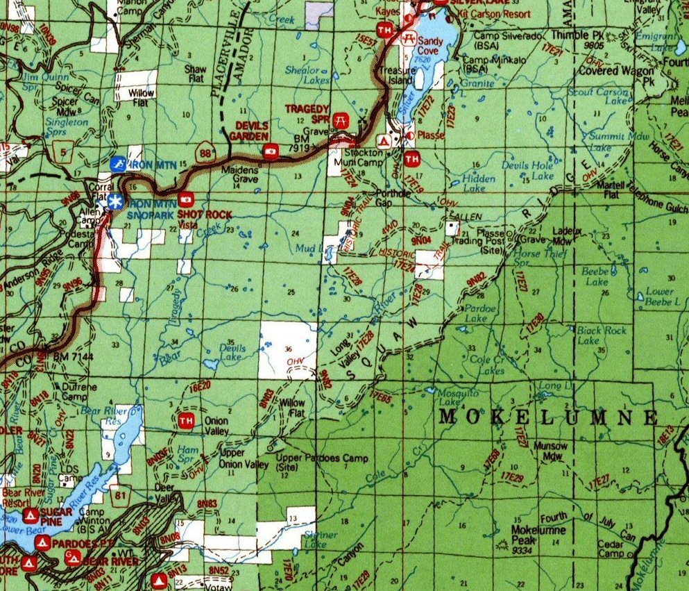
A link to the whole Eldorado National Forest Map (9MB)http://www.gentryoffroad.com/php/map...oradoblank.jpg
According to http://www.norcalttora.com/trails/pardoe.php the trail gets harder the further you go.
This picture from norcalttora is further than I went.

I ran the trail with a SAS, 32" A/T tires, and a rear locker.
A stock truck should expect to drag on rocks, air down, require spotting, stack rocks and may need occasionally pulled.
A link to the whole Eldorado National Forest Map (9MB)http://www.gentryoffroad.com/php/map...oradoblank.jpg
According to http://www.norcalttora.com/trails/pardoe.php the trail gets harder the further you go.
This picture from norcalttora is further than I went.
I ran the trail with a SAS, 32" A/T tires, and a rear locker.
A stock truck should expect to drag on rocks, air down, require spotting, stack rocks and may need occasionally pulled.
Jan 20, 2010 | 09:21 AM
#114
Registered User
Joined: Mar 2008
Posts: 6,059
Likes: 101
From: Sacramento, CA
a completely stock truck with 31s will probably require that... but what about a 4runner with 33 trxus MTs, bj spacer lift, ome 901 coils, sliders, 4.88s and locked front and back? will I do fine on pretty much every part of the trail? the plan is to have all of that by the time I go on the trip. I also have a TJM front bumper which really helps my approach angle over the stock bumper.
Jan 20, 2010 | 09:35 AM
#115
Registered User
Joined: Apr 2009
Posts: 535
Likes: 0
From: Suisun City, California
a completely stock truck with 31s will probably require that... but what about a 4runner with 33 trxus MTs, bj spacer lift, ome 901 coils, sliders, 4.88s and locked front and back? will I do fine on pretty much every part of the trail? the plan is to have all of that by the time I go on the trip. I also have a TJM front bumper which really helps my approach angle over the stock bumper.
Jan 20, 2010 | 09:43 AM
#116
Registered User
Joined: Mar 2008
Posts: 6,059
Likes: 101
From: Sacramento, CA
damn 9250 elevation? never been that high without being in an airplane... hahaha looking at the pictures though that place is fricking amazing looking. is there anything I should worry about as far as taking my truck up to that elevation?
Jan 20, 2010 | 09:50 AM
#118
Thread Starter
Registered User
Joined: Oct 2008
Posts: 1,621
Likes: 7
From: Sacramento, Crawlifonia
thanks for the info. whokrz.
Jan 20, 2010 | 11:32 AM
#119
Thread Starter
Registered User
Joined: Oct 2008
Posts: 1,621
Likes: 7
From: Sacramento, Crawlifonia
well im going to plan the PRERUN for the weekend of 29 of May. we will meet up at safeway in Pollock Pine at 8am. let me know who wants to make the PRERUN. if you all want i could make a second trip thread for the PRERUN.
My plan is to track the time too see how long it takes use to get through the trail. Also take pics and vids of clearance.
My plan is to track the time too see how long it takes use to get through the trail. Also take pics and vids of clearance.


