
Hackberry Creek - Saturday OCT 13
 Sep 10, 2007 | 01:15 PM
#1
Thread Starter
Registered User
Joined: Aug 2004
Posts: 976
Likes: 0
From: AZ
Hackberry Creek - Saturday OCT 13
Hackberry Creek/Powerline Trail, AZ
When Saturday, October 13 - 8:30AM
Where: Meet @ Los Hermanos Restaurant/Rest Stop in Superior, AZ - located on the southern side of the US 60 highway. I will be in a tan Toyota flatbed pickup. We will leave the rest stop at 9AM
To reach this area, travel EAST on HWY 60 through Mesa, past Apache Junction and continue on into the small town of Superior (map below)
What to expect :
Difficulty - This trail is a moderately challenging trail with some optional more difficult routes/obstacles. The trail consists of some steep and loose hill climbs/decents, combined with ledges and good sized rocks to negotiate. Updated: Expect some brush through the wash section too.
Minimum vehicle requirements: 4x4, 31" tires (minimum - sliders HIGHLY recommended if under 33" tires), Rear locker, spare tire, solid tow points front and rear.
Suggested vehicle recommendations: Sliders, 2" lift or more...
Est. Length: All Day - Bring a lunch and beverages.
The Hackberry Creek/Powerline trail system is located east of Superior, AZ. It is a scenic area, with lots of interesting geological formations. We will also make a side trip to the Devils Canyon area. This is a large, deep canyon. Great photo opportunity, lots to see. Dont forget the camera...
Map to meeting area:
http://maps.google.com/maps?hl=en&um...num=1&ct=image
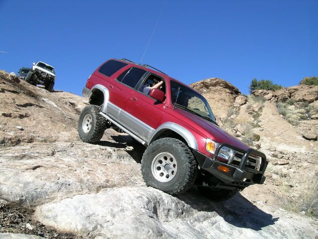
Trail Photos from previous runs -

Devils Canyon -

When Saturday, October 13 - 8:30AM
Where: Meet @ Los Hermanos Restaurant/Rest Stop in Superior, AZ - located on the southern side of the US 60 highway. I will be in a tan Toyota flatbed pickup. We will leave the rest stop at 9AM
To reach this area, travel EAST on HWY 60 through Mesa, past Apache Junction and continue on into the small town of Superior (map below)
What to expect :
Difficulty - This trail is a moderately challenging trail with some optional more difficult routes/obstacles. The trail consists of some steep and loose hill climbs/decents, combined with ledges and good sized rocks to negotiate. Updated: Expect some brush through the wash section too.
Minimum vehicle requirements: 4x4, 31" tires (minimum - sliders HIGHLY recommended if under 33" tires), Rear locker, spare tire, solid tow points front and rear.
Suggested vehicle recommendations: Sliders, 2" lift or more...
Est. Length: All Day - Bring a lunch and beverages.
The Hackberry Creek/Powerline trail system is located east of Superior, AZ. It is a scenic area, with lots of interesting geological formations. We will also make a side trip to the Devils Canyon area. This is a large, deep canyon. Great photo opportunity, lots to see. Dont forget the camera...
Map to meeting area:
http://maps.google.com/maps?hl=en&um...num=1&ct=image
Trail Photos from previous runs -
Devils Canyon -
Last edited by westy44runner; Sep 17, 2007 at 08:55 AM.
 Sep 10, 2007 | 08:06 PM
#7
Thread Starter
Registered User
Joined: Aug 2004
Posts: 976
Likes: 0
From: AZ
As for those who cannot make this trip - Tim and Mike - we will plan another trip for Hackberry come beginning of '08.
Trending Topics
Oct 6, 2007 | 10:44 AM
#11
Thread Starter
Registered User
Joined: Aug 2004
Posts: 976
Likes: 0
From: AZ
The run is still scheduled for next Saturday. Alittle update however, it is likely I will be leading the run from another vehicle - my truck blew the head gasket a couple weeks ago and I do not believe it will be ready in time for Saturday.
Chinito - come on out, we will look for you at Hermanos.
Chinito - come on out, we will look for you at Hermanos.
Oct 8, 2007 | 08:13 AM
#12
Oct 8, 2007 | 09:44 AM
#13
Thread Starter
Registered User
Joined: Aug 2004
Posts: 976
Likes: 0
From: AZ
haha yeah I wish. I have no doubt the FJ could probably complete the entire trail w/ the locker + a-trac, but at the cost of front & rear mangled bumpers and some bashed up rocker panels. The street tires they come with are worthless too...those rocks would slice the sidewalls like butter.
Are you bringing out the new ride??
Are you bringing out the new ride??
Oct 8, 2007 | 02:03 PM
#15
Thread Starter
Registered User
Joined: Aug 2004
Posts: 976
Likes: 0
From: AZ
Oct 11, 2007 | 07:06 AM
#19
Registered User
Joined: Aug 2006
Posts: 1,691
Likes: 2
From: Colorado Springs, Co
 . Just post up how the run went.

Thread
Thread Starter
Forum
Replies
Last Post
IntoTheVoid
Trip-Trail Reports & Photos
41
Oct 24, 2015 04:54 PM
JookUpVandetti
86-95 Trucks & 4Runners
10
Sep 30, 2015 08:58 AM


