
anza borego trails feb 17-18
 Feb 12, 2007 | 07:31 PM
#1

Thread Starter
Registered User
Joined: May 2006
Posts: 11
Likes: 0
anza borego trails feb 17-18
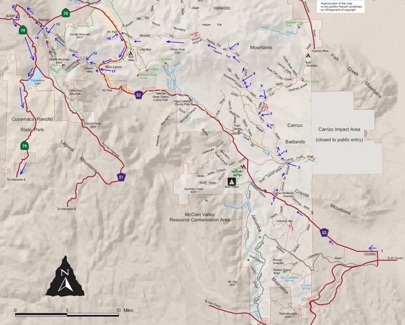
this coming weekend (feb 17-18), I am hoping to go 4-wheeling after FUD 200 race (that will be taking place by Ocotillo/Plaster City area on Saturday morning; I'll be pitting for a friend there but should be free by about 12pm-2pm I think). I am hoping to do something like this (follow the blue arrows) - from Ocotillo take imperial highway (S2) to canyon sin nombre, then onto arroyo seco del diablo, thru diablo drop-off to fish creek canyon, then either visit wind caves by following east thru fish creek wash and then coming back to the junction and continuing west on fish creek wash to the hapaha flat road or just go straight west thru fish creek wash to hapaha flat road, take that to Pinyon drop-off, drive it backwards (up, including heart-attack hill and the squeeze) and continue back to S2 on Pinyon mountain road. Then take S2 a little south to rodriguez canyon road and take that (or a little detour thru oriflamme canyon and chariot canyon) to road 78, then 78 east to 79 south, to 8, and back to san diego. Most probably camp out nearby number 9 on the map on Saturday night and then continue on Sunday morning. Planning to come bach to San Diego by 2pm or so.
preview:

the squeeze

heart-attack hill

etc...
anybody wants to come?
preview:
the squeeze
heart-attack hill
etc...
anybody wants to come?
Feb 13, 2007 | 06:58 AM
#3
Contributing Member
Joined: Oct 2002
Posts: 2,724
Likes: 0
From: Santee, CA
It is listed as 1 way...but I don't think they can enforce it. Better be double locked to get up Heartattack hill.
I would like to go this weekend, but the Inlaws will be in town.
I would like to go this weekend, but the Inlaws will be in town.
Last edited by Marc P; Feb 13, 2007 at 06:59 AM.
Feb 13, 2007 | 07:01 AM
#4
Thread Starter
Registered User
Joined: May 2006
Posts: 11
Likes: 0
I believe for safety reasons it is called out on the map as one way, but people have driven it up (backwards) before as well, although it can be really hard to make it up the heart-attack hill I heard, so rear locker would be a requirement I believe. I've never tried it before and if we can't make it up we can always reroute - probably get out thru fish creek wash east. I do have a winch though (warn M8000) that we could put to a good test as well. 
Feb 13, 2007 | 07:07 AM
#5
Thread Starter
Registered User
Joined: May 2006
Posts: 11
Likes: 0
little background info:
While I drove around the desert by Ocotillo/Superstition/Sand Dam somewhat a lot, I am quite unfamiliar with the planned route, except for running canyon sin nombre and down carrizo creek wash to the east.
I drive a 2003 double cab tacoma, 4x4 with rear trd locker, 31" bfg mt tires, about 2" lift, and NO sliders. I do have an M8000 winch, as well as high lift, some aluminum boards to use as sand-ladders, shovel, strap, and a small hand winch. Also have snorkel and a cb.

 Feb 13, 2007 | 07:14 AM
#7
Registered User
Joined: Apr 2004
Posts: 2,969
Likes: 1
From: San Diego CA
I believe for safety reasons it is called out on the map as one way, but people have driven it up (backwards) before as well, although it can be really hard to make it up the heart-attack hill I heard, so rear locker would be a requirement I believe. I've never tried it before and if we can't make it up we can always reroute - probably get out thru fish creek wash east. I do have a winch though (warn M8000) that we could put to a good test as well.
So, you're one of the reasons that things is getting more and more rutted. I think tread lightly also applies to the requests written on the maps. Just seems kinda obvious. Just because it has been done doesn't mean that it should be done.

Trending Topics
Feb 13, 2007 | 08:47 AM
#8
Registered User
Joined: Nov 2005
Posts: 228
Likes: 0
From: PBSDCAUSA
you definatly could make it up with the right line choices, but as deathrunner stated this is the reason these areas are getting more rutted and even closed.
the diablo dropoff has about 17,000 trails going down it now, none of which are hard, but with the stay on trail sign right there it doesnt look good for us as a community.
That said, I know Viter, have wheeled with him here and in Baja and he is a standup guy, and responsible off roader. I would be there wheeling with ya Ilya but cant...
Mike
Feb 13, 2007 | 08:59 AM
#9
Thread Starter
Registered User
Joined: May 2006
Posts: 11
Likes: 0
thanks for the reference Mike!
as far as tearing things up - I don't plan to (I never seen this place before in person, only in pictures, and I'd like to see it and go from there since it is always easier to judge things in reality than by looking at pictures; if it looks too hard I'll turn around and get out thru fish creek wash east as mentioned earlier), as far as one-way designation on the map - I still think it is more there for safety reasons than anything else, cosnidering maps are made for general public and I am sure drivers in stock vehicles use it too.
I appreciate your pictures and advice Mark P!
so does anybody want/can come?
Feb 13, 2007 | 12:16 PM
#10
Contributing Member
Joined: Apr 2006
Posts: 540
Likes: 0
From: San Diego
I can't come with you, already have plans, but maybe you should just head out on the 78 and run that path going the opposite way planned. Going UP rodriguez canyon seems like it would be tough in the two rock parts, and since you aren't really supposed to do the squeeze going west, that would also fix that problem. Now you will be taking canyon sinombre backwards, but that seems better than taking hearattack and squeeze backwards. Then you could head back to the 8 and bail back to SD. Just my thoughts. Enjoy.
Feb 13, 2007 | 01:03 PM
#11
Registered User
Joined: Nov 2005
Posts: 228
Likes: 0
From: PBSDCAUSA
I can't come with you, already have plans, but maybe you should just head out on the 78 and run that path going the opposite way planned. Going UP rodriguez canyon seems like it would be tough in the two rock parts, and since you aren't really supposed to do the squeeze going west, that would also fix that problem. Now you will be taking canyon sinombre backwards, but that seems better than taking hearattack and squeeze backwards. Then you could head back to the 8 and bail back to SD. Just my thoughts. Enjoy.
Feb 13, 2007 | 03:09 PM
#12
Thread Starter
Registered User
Joined: May 2006
Posts: 11
Likes: 0
yep, Mike is right
I looked at the area on Goolge some more and figured I could even continue on Fish creek wash going north pretty much up to 78 if the heart-attack hill turns out too hard, so I think I have my plans a and b figured out now.
I looked at the area on Goolge some more and figured I could even continue on Fish creek wash going north pretty much up to 78 if the heart-attack hill turns out too hard, so I think I have my plans a and b figured out now.
Feb 13, 2007 | 06:24 PM
#14
Contributing Member
Joined: Oct 2002
Posts: 2,724
Likes: 0
From: Santee, CA
I uploaded this video to give you an idea of why they call it "Heartattack" hill.....never mind all the brake noise
http://www.youtube.com/watch?v=ZEC4oN3Q9Xg
http://www.youtube.com/watch?v=ZEC4oN3Q9Xg
Feb 13, 2007 | 06:45 PM
#15
Registered User
Joined: May 2006
Posts: 130
Likes: 0
From: San Diego
I uploaded this video to give you an idea of why they call it "Heartattack" hill.....never mind all the brake noise
http://www.youtube.com/watch?v=ZEC4oN3Q9Xg
http://www.youtube.com/watch?v=ZEC4oN3Q9Xg


 Feb 13, 2007 | 07:12 PM
#20

Contributing Member
Joined: Mar 2005
Posts: 1,909
Likes: 0
Steve the Lexus would absolutely not fit. I have scrapes on both side from it. I know you could do the obstacle if it would fit. It is not that hard especially with a spotter that you trust.
Heart attack is really taking a beating from the backward traffic. The ruts are getting super bad. Just not a great idea if we want to keep the land usage nazi's off our back and the trail open.
Have fun!
Heart attack is really taking a beating from the backward traffic. The ruts are getting super bad. Just not a great idea if we want to keep the land usage nazi's off our back and the trail open.
Have fun!


