
Teach me about GPS, please
 Jan 25, 2007 | 08:43 AM
#1
Thread Starter
Contributing Member
Joined: Jul 2002
Posts: 2,657
Likes: 0
From: Colorado
Teach me about GPS, please
I've spent some time reading a few of the threads here. But, I'm still lost. I know what GPS is, and I know how it works. But, I need to know what kind of equipment I need and the best place to get it.
I have a Compaq laptop running Windows XP and an AMD Athlon processor. I know I need an antenna and software. I want to be able to enter specific coordinates and have directions. I also want to be able to enter an address to get directions. What can you recommend that will accomplish this?
Thank you!
Jan 25, 2007 | 09:10 AM
#2
Contributing Member
Joined: Jan 2005
Posts: 648
Likes: 0
From: Mill Creek, Washington
I am sure there will be a lot of different opinions on this one so I will just tell you what I have and what I use it for.
I have a Garmin GPS. I use the GPS76. I connect it to my laptop and use the delorme topo USA software. This software is very easy to use. Has all the maps in the US (including most trails). I have found it to be pretty accurate and for around $100 its a pretty good deal. I don't use an antenna. I just mount the gps on my dashboard with a couple pieces of velcro. This setup works very well for me.
The software makes it easy to put in coordinates and addresses. By creating map layers you can add and remove coordinates.
I recently used this setup for a desert race in Nevada where we had to map out well over 100 coordinates. I have also used it for local geocaching or just my own personal mapquest.
I like the delorme stuff becuase it comes on 2 DVDs and is easy to move to other computers. (no registration).
I also use OziExplorer but it is a bit more complex to use.
http://www.garmin.com/products/gps76/
http://shop.delorme.com/OA_HTML/DELi...050&item=23968
Last edited by Mickdady; Jan 25, 2007 at 09:14 AM.
Jan 25, 2007 | 09:20 AM
#3
Contributing Member
Joined: Jan 2005
Posts: 648
Likes: 0
From: Mill Creek, Washington
I should also add some details about how the communication works between the GPS and laptop.
So if you are out in the woods with just the laptop and you use the track feature or you just mark a waypoint (say a cool viewpoint or wheeling spot). When you plug into your laptop it will add the route or waypoints in. You just go to the GPS option and pick upload or download.
If you add points into your laptop and want to upload them into your GPS you just click upload and choose the maplayer and points to upload. This lets you disconnect from the laptop and walkinto th woods or desert to find the waypoint. Especially usefull for geocaching. The GPS will have a "go to" function and you just pick the waypoint you want to go to and it will lead you. (quite accurately too!).
let me know if you have any other questions.
Jan 25, 2007 | 10:18 AM
#4
Contributing Member
Joined: Dec 2003
Posts: 2,893
Likes: 2
From: Fort Worth, TX
I personally would recommend a stand-along GPS unit that you could mount on your windshield, because looking down at your computer is a no-no... plus it would take up a lot of space.
Here's a whole bunch of units:
http://www.garmin.com/automotive/pro...tml#automotive
It's worthwhile to note that many GPS units can be plugged into a laptop to use the laptop as the screen, in addition to adding more detailed maps and such.
if you must go with just a GPS receiver for the laptop, I might go with something like this:
http://www.westcoin.com/ggps18.html
For GPS units I feel there is one universal truth: Screen size and resolution is everything, followed closely by available maps and battery life (for portables).
Jan 25, 2007 | 10:30 AM
#5
Registered User
Joined: Aug 2006
Posts: 1,523
Likes: 0
From: Maryland
if you want to use your laptop, check out costco they had a gps antenna a while back for around $100, my neighbor bought one and it works great. as far as using them, it's more trial and error than anything. there are obvious options you don't want, that will be in the menu.
i had a garmin handheld in the army, it was just el-cheapo but it worked pretty good, now i have a magellan meridian, with the street software, and i like it alot better, not as user friendly but built alot tougher. it's 100% waterproof and the SOB even floats.
i had a garmin handheld in the army, it was just el-cheapo but it worked pretty good, now i have a magellan meridian, with the street software, and i like it alot better, not as user friendly but built alot tougher. it's 100% waterproof and the SOB even floats.
Jan 25, 2007 | 10:36 AM
#7
Banned - User requested
Joined: Feb 2003
Posts: 3,496
Likes: 0
From: earth
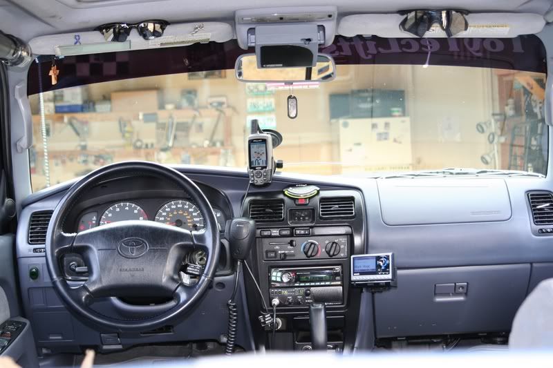
I have the 60CS I like it, about all Im using it for now is tracking the runs, I need to get some software, Im thinking about getting the N.G. software, then I can pre plan trips, as Im wanting to start exploring the western slope.
but its a great little unit, I have the windshield mount, when wheeling, but "if" I want to go hiking its small enough to put in a pocket. Color screen, I do have the external antenna, which seems to help when in a valley with tree coverage.
Im still new with GPS, Im much better with a paper topo map and a compass thankx to Uncle Sam, lol
oh you can also take a class at REI its free they also have the Map and Compass class for free, what if you loss power while on the trail ? ya shopuld know how to read a map and compass. I taken both the classes, they are great refresher classes, its almost time to retake them, lol
Trending Topics
Jan 25, 2007 | 05:35 PM
#8

Registered User
Joined: May 2006
Posts: 252
Likes: 0
From: Tempe, AZ
I would definitely recommend Garmin over the other consumer brands. I use GPS for work on a very regular basis and have tried out pretty much all of them.
If you plan on wheelin' and hikin' get one that is rugged. I have a Garmin Map76s and an etrex vista. You can pick up an external antenna on ebay for around $10 and possibly a ram mount for pretty cheap. How you mount the GPS (permanent, velcro, suction, etc.) and where you mount it is up to you. The external antennas have a magnetic base and plenty of cable so you can throw it on the roof.
I'd also recommend you get a unit that accepts maps.
you'll need to buy the Garmin TopoUSA series ($80) for that. They have several sets: The standard is based off of USGS 1:100k scale maps. Not too good for detail, but it at least will have trails (both hiking and wheelin'). THey also make a National Parks series divided into eastern and western US. These are based off of USGS 1:24k maps. Much better detail with these, but only useful for National Parks. And they don't currently do not cover all the parks. Also available are city guide maps for urban travel.
If you want to just use the maps on your pc, go with Delorme or national geographic.
check out http://4x4books.com/
they're fast, friendly, and usually have the best price around.
Jan 26, 2007 | 02:21 AM
#11
Registered User
Joined: Dec 2002
Posts: 4,655
Likes: 0
From: Idaho
HaveBlue.... Look at Garmins. Find a hand held that suits your needs. If you hike or hunt any I suggest the eTrex Series, small and versitile. I perfer the Vista C, or Cx. Then install their software on your laptop, and download nroute from their website. nroute is moving map software, so you put the GPS on the dash hook it up via USB to the laptop and away you go. The other Garmin software is mapsource, this allows you to review routes, tracks, waypoints, and maps on your laptop then download what you need to the GPS. One reason I reccommend the C is they use mini-USB, not serial like the non color ones... 10x faster on uploads and downloads. Garmin also sells topo and city map software that if you get a compatible GPS, most are, you can see the map on your GPS screen, or the laptop with nroute. Gramins truly are a great setup.
Jan 26, 2007 | 05:33 AM
#12
Thread Starter
Contributing Member
Joined: Jul 2002
Posts: 2,657
Likes: 0
From: Colorado
Thanks for all the feedback. So, from what I gather, it's best to get a handheld unit instead of just getting an antenna and software for my laptop?
Also, with the Garmin eTrex, can I enter specific coordinates and will it give me waypoint markers?
Also, with the Garmin eTrex, can I enter specific coordinates and will it give me waypoint markers?
Last edited by HaveBlue; Jan 26, 2007 at 05:40 AM.
Jan 26, 2007 | 05:43 AM
#13
Registered User
Joined: Dec 2002
Posts: 4,655
Likes: 0
From: Idaho
2. Yes, you can do that on the GPS or the computer, and download it to the GPS.
Jan 29, 2007 | 04:39 PM
#14
Contributing Member
Joined: Apr 2006
Posts: 540
Likes: 0
From: San Diego
First, let me admit that I haven't searched very hard on this, but have a question that no one seems to be able to answer to date. What I would like to do is download topo maps or an jpeg etc photo and make it into a gps map. Are any of you guys making your own gps topo maps. I don't have much use for on road maps, and I'm afraid most of the places where I would want gps will not be on the maps that you can purchase. Any thoughts?
Jan 29, 2007 | 04:43 PM
#15
Registered User
Joined: Dec 2003
Posts: 677
Likes: 0
From: Encinitas, CA
Lots of information about how GPS works.
http://flash.aopa.org/asf/gps_vfr/flash.cfm
& I love me my Garmin 60C with topo software and aux antenna!
http://flash.aopa.org/asf/gps_vfr/flash.cfm
& I love me my Garmin 60C with topo software and aux antenna!
Jan 30, 2007 | 03:17 PM
#16
Registered User
Joined: Dec 2002
Posts: 4,655
Likes: 0
From: Idaho
First, let me admit that I haven't searched very hard on this, but have a question that no one seems to be able to answer to date. What I would like to do is download topo maps or an jpeg etc photo and make it into a gps map. Are any of you guys making your own gps topo maps. I don't have much use for on road maps, and I'm afraid most of the places where I would want gps will not be on the maps that you can purchase. Any thoughts?
3
Garmin Topo
Last edited by AH64ID; Jan 30, 2007 at 03:26 PM.
Feb 5, 2007 | 08:59 PM
#17
Contributing Member
Joined: Apr 2003
Posts: 737
Likes: 0
From: The rolling hills of Cavan, Ontario
The $200 solution...
I recently picked up a used Ipaq 4350 PDA for $150 and a Bluetooth GPS receiver for $35. I use software called GPSDash (for pocket PC) and can make maps straight outta Google Earth, so I can have maps at any scale for anywhere in the world. I really should post pics with this. The PDA can run MS Streets for highway needs if required. The PDA hangs from the rearview mirror and the bluetooth GPS goes on the dash. The battery on the units run for about 8 hours on a full charge, but the GPS came with a 12 volt power cord that charges both units
The bonus is that the PDA also plays MP3's, runs SKYPE via wifi and all the other neat things a PDA does.
I also have a stand-alone GPS (Garmin) and a "mouse-type" USB GPS that I can hook to a laptop. All I ever use now (in the truck) is the PDA/Bluetooth combo. Very versatile and relatively cheap, too.
If your looking for a new GPS, go with something that has SIRF2 or SIRF 3 chip in it...faster aquisition and signal lock.
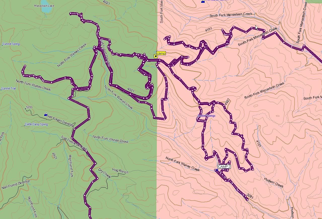
I use mine on the highway and on unmarked trails. One of the really neat parts is that you can record your data stream and review it at a later time. As an example, on my last trip to Whitefish Lake my average trail speed was less than 10 mph. Some may say "what's the use in that?" Well it was a great way to show my wife that I wasn't goofing around on the trails with my 8 yr old in the back. I just didn't show her the "altitude" function, with all the ups and downs we went through.
Whatever way you go, pick one that is easy to use (for you). That way you'll get great use out of it and it won't just sit in the glovebox. Enjoy!
I recently picked up a used Ipaq 4350 PDA for $150 and a Bluetooth GPS receiver for $35. I use software called GPSDash (for pocket PC) and can make maps straight outta Google Earth, so I can have maps at any scale for anywhere in the world. I really should post pics with this. The PDA can run MS Streets for highway needs if required. The PDA hangs from the rearview mirror and the bluetooth GPS goes on the dash. The battery on the units run for about 8 hours on a full charge, but the GPS came with a 12 volt power cord that charges both units
The bonus is that the PDA also plays MP3's, runs SKYPE via wifi and all the other neat things a PDA does.
I also have a stand-alone GPS (Garmin) and a "mouse-type" USB GPS that I can hook to a laptop. All I ever use now (in the truck) is the PDA/Bluetooth combo. Very versatile and relatively cheap, too.
If your looking for a new GPS, go with something that has SIRF2 or SIRF 3 chip in it...faster aquisition and signal lock.
I use mine on the highway and on unmarked trails. One of the really neat parts is that you can record your data stream and review it at a later time. As an example, on my last trip to Whitefish Lake my average trail speed was less than 10 mph. Some may say "what's the use in that?" Well it was a great way to show my wife that I wasn't goofing around on the trails with my 8 yr old in the back. I just didn't show her the "altitude" function, with all the ups and downs we went through.
Whatever way you go, pick one that is easy to use (for you). That way you'll get great use out of it and it won't just sit in the glovebox. Enjoy!

Thread
Thread Starter
Forum
Replies
Last Post
charlie_fong
General Vehicle Related Topics (Non Year Related)
0
Sep 27, 2015 10:06 PM


