
Northern AZ Explore
 Aug 30, 2008 | 11:30 PM
#1
Thread Starter
Contributing Member
Joined: Jun 2005
Posts: 3,415
Likes: 10
From: Phx, AZ
Northern AZ Explore
Had a few days off so I thought I'd take the dog up and around AZ. No specific plan, just hit the Rim and then make my way over to Jerome/ Prescott area.
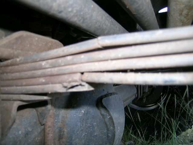
Unfortunately, my PS front leaf spring failed on day two... so had to cut the trip shorter than planned.
Photo of the guilty party.
First afternoon we hiked into Clear Creek. No trail, just one of the many access canyons that leads to the bottom. Lot's of dead fall in the way which made progress more difficult.
The start (and camp spot):

Magic Mushroom:

Nice creek at the bottom:

Clear almost blue water with many, many crawdads scurrying about:

There is a cliff face with a lot of petroglyphs. My guess is some if not all are made more recently than the patterns would suggest, but cool none the less. :
:


After some exploring, it was time to head back up. Had to give the dog a boost or two to get up the steeper sections. Looking towards the goal:

We camped at the trail head. With some sunlight left, I did some map scouting and found a route that would take me mostly on dirt up to the StoneMan Lake turnoff. After marking the GPS with some important turns, the dog and I hit the hay.
One last look back down:

On to day two...
Unfortunately, my PS front leaf spring failed on day two... so had to cut the trip shorter than planned.
Photo of the guilty party.
First afternoon we hiked into Clear Creek. No trail, just one of the many access canyons that leads to the bottom. Lot's of dead fall in the way which made progress more difficult.
The start (and camp spot):
Magic Mushroom:
Nice creek at the bottom:
Clear almost blue water with many, many crawdads scurrying about:
There is a cliff face with a lot of petroglyphs. My guess is some if not all are made more recently than the patterns would suggest, but cool none the less.
:After some exploring, it was time to head back up. Had to give the dog a boost or two to get up the steeper sections. Looking towards the goal:
We camped at the trail head. With some sunlight left, I did some map scouting and found a route that would take me mostly on dirt up to the StoneMan Lake turnoff. After marking the GPS with some important turns, the dog and I hit the hay.
One last look back down:
On to day two...
Last edited by Elvota; Aug 30, 2008 at 11:52 PM.
Aug 30, 2008 | 11:42 PM
#2
Thread Starter
Contributing Member
Joined: Jun 2005
Posts: 3,415
Likes: 10
From: Phx, AZ
We started to make our way across the plains of Northern AZ. At first, the road was very tame, all 2WD stuff. Then finally came across a sign stating "no maintenance beyond this point". Good news for me.
Road to somewhere:

Mostly flatland with amazing views. Road got rougher with some biggish mudholes and rocks, but nothing to bad. Came across a mountain, so decided to find out what was at the top.
Nothing much but a fire tower and a sign:

And some really great views:

The cliffs of Sedona can be seen near the horizon in this one:

The trail got progressively less used and faint until almost the only way to tell which way to go was a red line on the GPS.
Not to many people go this way anymore:

The firetower mountain with the views can be seen in the background here:

After stumbling along for a bit the trail became slightly more challenging. Just when I thought we were totally lost, asphalt popped up and we headed down through Jerome and into Prescott.
Ended up finding a great new spot to rest our heads in Prescott after discovering all my old trails had either been gated or removed courtesy of the ever active Forest Service.
Camp 02:

View from camp:

The glory that is Toyota :
:

Backdrop:

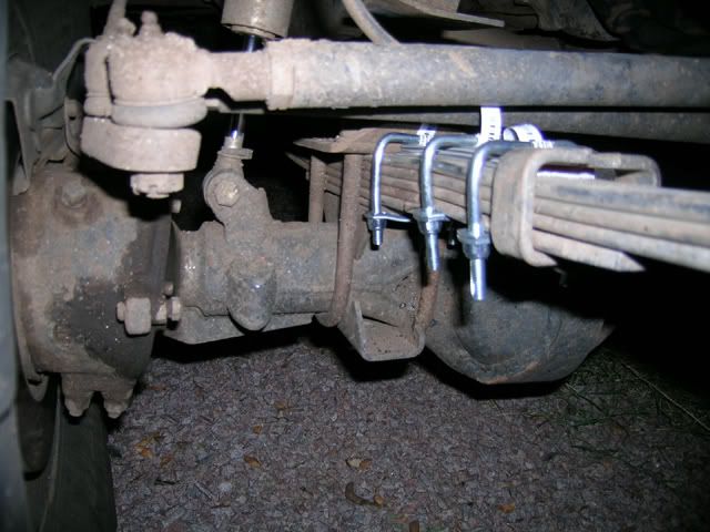
That night before turning in I discovered the broken spring, and had to call it a trip. Stopped by True Value in the morning and did what I could to make sure things stayed where they should for the trip home:
So Smiley Rock still lies undone... maybe I'll have better luck next time.
Road to somewhere:
Mostly flatland with amazing views. Road got rougher with some biggish mudholes and rocks, but nothing to bad. Came across a mountain, so decided to find out what was at the top.
Nothing much but a fire tower and a sign:
And some really great views:
The cliffs of Sedona can be seen near the horizon in this one:
The trail got progressively less used and faint until almost the only way to tell which way to go was a red line on the GPS.
Not to many people go this way anymore:
The firetower mountain with the views can be seen in the background here:
After stumbling along for a bit the trail became slightly more challenging. Just when I thought we were totally lost, asphalt popped up and we headed down through Jerome and into Prescott.
Ended up finding a great new spot to rest our heads in Prescott after discovering all my old trails had either been gated or removed courtesy of the ever active Forest Service.
Camp 02:
View from camp:
The glory that is Toyota
:Backdrop:
That night before turning in I discovered the broken spring, and had to call it a trip. Stopped by True Value in the morning and did what I could to make sure things stayed where they should for the trip home:
So Smiley Rock still lies undone... maybe I'll have better luck next time.
Last edited by Elvota; Aug 30, 2008 at 11:53 PM.
 Sep 3, 2008 | 12:01 PM
#7
Registered User
Joined: Aug 2006
Posts: 111
Likes: 0
From: Peoria AZ
By Clear creek I assume you mean West clear creek? Is the lookout tower southeast of Stoneman lake?
Looks like a good time, good thing you noticed teh spring before hittin the highway home......
Thanks for sharing.
Looks like a good time, good thing you noticed teh spring before hittin the highway home......
Thanks for sharing.
Trending Topics
Sep 3, 2008 | 12:19 PM
#8
Thread Starter
Contributing Member
Joined: Jun 2005
Posts: 3,415
Likes: 10
From: Phx, AZ
Yup, West Clear Creek. Lot's of areas to explore around their for sure.
Most likely... I just pieced together some roads off the TOPO to try and do as much dirt as possible between WCC and Stoneman Lake Road. Just came across the mountain and drove to the top.
I was planning on doing Smiley Rock and was bummed I couldn't. I haven't been able to hit that trail with others due to scheduling and thought I'd finally get a chance to run it this trip. Hoping to get things repaired this week so I can hit Log Corral on Saturday. 
Most likely... I just pieced together some roads off the TOPO to try and do as much dirt as possible between WCC and Stoneman Lake Road. Just came across the mountain and drove to the top.


Thread
Thread Starter
Forum
Replies
Last Post
FS[GreatLakes]: Wanted: 4.88 front diff, rear 8'' 4.88
jaretstuff
Axles - Suspensions - Tires - Wheels
1
Aug 4, 2015 02:08 PM


