
Living Overland's Four Corners Trip
 Nov 30, 2011 | 06:12 AM
#1
Thread Starter
Registered User
Joined: Aug 2006
Posts: 375
Likes: 0
From: The Big Wonderful
Living Overland's 2011 Four Corners Trip
It has been about a week since our 8-day trip to the Four Corners area and we have finally finished editing our photos and we are now starting on blog posts for each of the places we visited. We created an interactive map, thanks to Google Maps, where you will be able to click on a location to see an image of the site and a link to the post.

The main page also has a slideshow for all of the photos taken during the trip.
Here are some of the places we visited:
Head of Sinbad

Hole N" The Rock

Edge of the Cedars Museum/Pueblo

Hovenweep National Monument

Chaco Culture National Historic Park

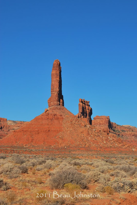
Valley of the Gods
Fallen Roof Ruin

The main page also has a slideshow for all of the photos taken during the trip.
Here are some of the places we visited:
Head of Sinbad
Hole N" The Rock
Edge of the Cedars Museum/Pueblo
Hovenweep National Monument
Chaco Culture National Historic Park
Valley of the Gods
Fallen Roof Ruin
Last edited by flyfishexpert; Nov 30, 2011 at 06:15 AM.
Nov 30, 2011 | 06:13 AM
#2
Thread Starter
Registered User
Joined: Aug 2006
Posts: 375
Likes: 0
From: The Big Wonderful
2011 Head of Sinbad
2011 Head of Sinbad
Head of Sinbad Pictograph
Location: N38 52' 48", W110 46' 13"
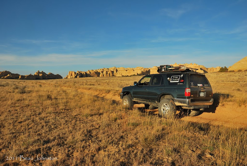
Driving in
Getting There: Access to the site is fairly easy, following unpaved frontage roads along Interstate 70. The roads were fairly good for our drive, but we would reccomend a vehicle with higher clearance due to very rutted roads.
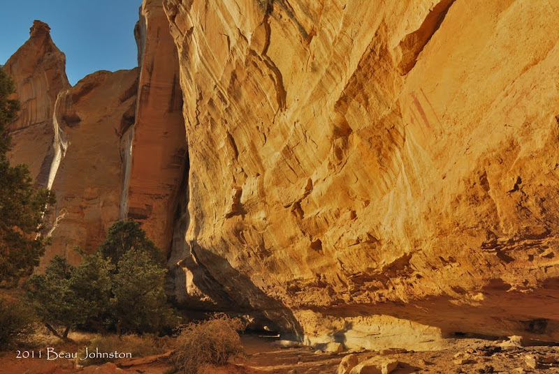
The cliff wall
Site Information: The site is home to the Head of Sinbad pictograph which is a very well preserved piece of rock art. We found two pictograph panels on the cliff wall, the above being the most notable and a second to the left.
More information on our visit to Head of Sinbad Pictrograph can be found by clicking here.
Head of Sinbad Pictograph
Location: N38 52' 48", W110 46' 13"
Driving in
Getting There: Access to the site is fairly easy, following unpaved frontage roads along Interstate 70. The roads were fairly good for our drive, but we would reccomend a vehicle with higher clearance due to very rutted roads.
The cliff wall
Site Information: The site is home to the Head of Sinbad pictograph which is a very well preserved piece of rock art. We found two pictograph panels on the cliff wall, the above being the most notable and a second to the left.
More information on our visit to Head of Sinbad Pictrograph can be found by clicking here.
Nov 30, 2011 | 06:13 AM
#3
Thread Starter
Registered User
Joined: Aug 2006
Posts: 375
Likes: 0
From: The Big Wonderful
Lone Warrior

Location:
N 38� 51.197 W 110� 48.225
Getting There:
Access to the site is fairly easy, following the same unpaved frontage roads along Interstate 70 as you would to go to the Head of Sinbad Pictograph. Instead of turning North and crossing under Interstate 70, continue following the frontage road as it turns South. A couple miles later you will see a sign for the turnoff to the site.
Site Information:
When you arrive at the parking area you will see two fenced off areas. The Lone Warrior Pictograph is located at the farthest with a pair of faint figures located at the first.
Notes About our Visit:
We arrived at the site late after our visit to the Head of Sinbad site. This location faces south east, so our lighting was less than ideal for taking photos. We spent approximately 15 minutes exploring the area before we headed off. I believe the best time to take photos of the pictograph would be first thing in the morning as it would provide better light.
Camping:
Although we did not camp here, the area looked perfect for finding an unimproved campsite in a secluded area. There were several spur roads that also looked like they would be fun to explore.
More information on our trip can be found on our main trip post by clicking here.
Nov 30, 2011 | 06:14 AM
#4
Thread Starter
Registered User
Joined: Aug 2006
Posts: 375
Likes: 0
From: The Big Wonderful
Recapture Pocket
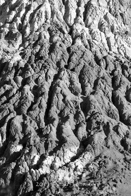
Recapture Pocket

Site Information:
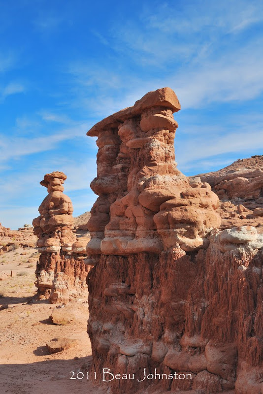
Recapture pocket is full of wonderful geologic formations eroded out of the bluff. Boulders sit stacked upon each other with only a layer of soil holding them together. Great fortress-like walls rise up out of the ground as if placed there to protect the royalty within. The features are so unlike anything else in this wash that they beckon the passerby to come and explore.

Notes About our Visit:
A big thanks to Ara, with The Oasis Of My Soul, for sharing this location with us! Also a big thanks to the wonderful folks at the Cadillac Ranch RV Park in Bluff for providing directions.
We arrived to the location about midday and spent nearly two hours photographing and walking through the area. We really enjoyed the site and would recommend it as a stop for anyone passing through the area. This area has been compared to New Mexico's Bisti Badlands, but in our opinions, it is a much more beautiful and unique area.
Camping:
Although the area offers ample sites for unimproved camping, we chose to drive back to CR217 and follow it east through Recapture Creek. Just past the creek a road takes off to the north. We followed this road to a series of sandstone outcroppings just above the creek floor. ( 37�19'43.07"N 109�27'20.19"W) We setup camp on one of these outcroppings, prepared dinner, and enjoyed the sunset before we crawled inside the 4Runner for the night.


More information on our trip and our visit to Recapture Pocket can be found on our main trip post by clicking here.
Site Information:
Recapture pocket is full of wonderful geologic formations eroded out of the bluff. Boulders sit stacked upon each other with only a layer of soil holding them together. Great fortress-like walls rise up out of the ground as if placed there to protect the royalty within. The features are so unlike anything else in this wash that they beckon the passerby to come and explore.
Notes About our Visit:
A big thanks to Ara, with The Oasis Of My Soul, for sharing this location with us! Also a big thanks to the wonderful folks at the Cadillac Ranch RV Park in Bluff for providing directions.
We arrived to the location about midday and spent nearly two hours photographing and walking through the area. We really enjoyed the site and would recommend it as a stop for anyone passing through the area. This area has been compared to New Mexico's Bisti Badlands, but in our opinions, it is a much more beautiful and unique area.
Camping:
Although the area offers ample sites for unimproved camping, we chose to drive back to CR217 and follow it east through Recapture Creek. Just past the creek a road takes off to the north. We followed this road to a series of sandstone outcroppings just above the creek floor. ( 37�19'43.07"N 109�27'20.19"W) We setup camp on one of these outcroppings, prepared dinner, and enjoyed the sunset before we crawled inside the 4Runner for the night.
More information on our trip and our visit to Recapture Pocket can be found on our main trip post by clicking here.
Dec 1, 2011 | 09:29 AM
#5
Thread Starter
Registered User
Joined: Aug 2006
Posts: 375
Likes: 0
From: The Big Wonderful
Hole N The Rock
Hole N The Rock
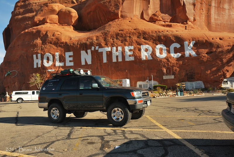
Location:
11037 S Highway 191
Moab, UT 84532

Getting There:
Hole N" The Rock is located approximately 12 miles south of Moab, UT along Highway 191. Signs painted high upon the sandstone direct both north and southbound travelers to the location.
More information on our trip and our visit to Recapture Pocket can be found on our main trip post by clicking here.
Location:
11037 S Highway 191
Moab, UT 84532
Getting There:
Hole N" The Rock is located approximately 12 miles south of Moab, UT along Highway 191. Signs painted high upon the sandstone direct both north and southbound travelers to the location.
More information on our trip and our visit to Recapture Pocket can be found on our main trip post by clicking here.
Dec 8, 2011 | 05:43 AM
#6
Thread Starter
Registered User
Joined: Aug 2006
Posts: 375
Likes: 0
From: The Big Wonderful
Edge of the Cedars State Park
Edge of the Cedars State Park
Location:
660 West 400 North
Blanding, UT 84511
Hours and Fees:
Open year-round
Monday-Saturday, 9 am-5 pm; closed Sunday
$5 for adults
$3 for children
Site Information:
Utah's Edge of the Cedars State Park is home to an ancient puebloen ruin and a museum. The pueblo dates back to between AD 825 and 1125 when it served as a major community for the Ancesteral Puebloen people.
Notes About our Visit:
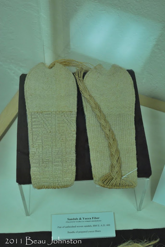
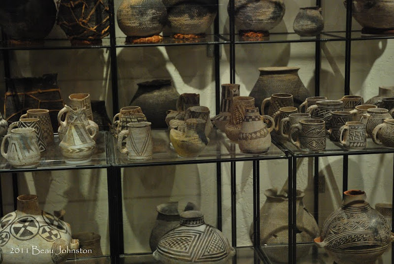
We were amazed by the museum's beautiful collection of area artifacts. We were in wonder as we walked from display to display gazing at everything from the turkey feather blankets to intricate designs of the arrows and spears. Time lines on the wall allowed us to see the Ancestral Puebloen people evolved their tool and pottery designs over the years. One item we found very intreguing was an amazingly preserved red and blue macaw feather sash, which shows the people's trade routes extended well into Central America.

More information on our trip and our visit to Edge of the Cedars State Park can be found here, on our main trip post by clicking here.
Location:
660 West 400 North
Blanding, UT 84511
Hours and Fees:
Open year-round
Monday-Saturday, 9 am-5 pm; closed Sunday
$5 for adults
$3 for children
Site Information:
Utah's Edge of the Cedars State Park is home to an ancient puebloen ruin and a museum. The pueblo dates back to between AD 825 and 1125 when it served as a major community for the Ancesteral Puebloen people.
Notes About our Visit:
We were amazed by the museum's beautiful collection of area artifacts. We were in wonder as we walked from display to display gazing at everything from the turkey feather blankets to intricate designs of the arrows and spears. Time lines on the wall allowed us to see the Ancestral Puebloen people evolved their tool and pottery designs over the years. One item we found very intreguing was an amazingly preserved red and blue macaw feather sash, which shows the people's trade routes extended well into Central America.
More information on our trip and our visit to Edge of the Cedars State Park can be found here, on our main trip post by clicking here.

Trending Topics
Dec 19, 2011 | 12:33 PM
#8
Thread Starter
Registered User
Joined: Aug 2006
Posts: 375
Likes: 0
From: The Big Wonderful
Hovenweep National Monument
Hovenweep National Monument
Notes About Our Visit:
We arrived at the Hovenweep visitor center about midday and quickly set off to walk the 2-mile Square Tower Group Trail which leads from the visitor center out to and around the canyon. We took the recommended 1-1/2 hour time to explore and take photos and found it to be more than enough for a quick walk. After we setup camp I returned to the Hovenweep Castle Tower area to take some sunset photos.
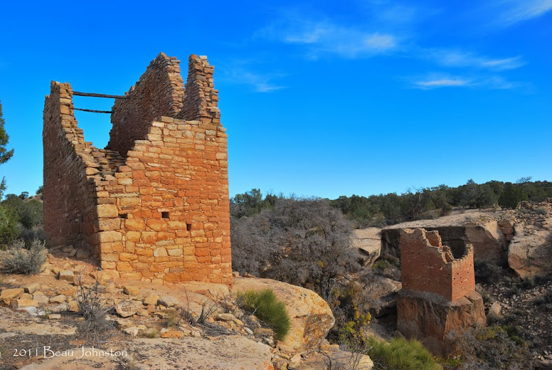
The next morning we woke up, picked up camp, and headed off to the three outlying cliff ruins. We used the area map provided by the visitor center to make our way to the other ruins. Access to the ruins outside the main area is over dirt roads, which in spots were fairly rocky but not bad. We really enjoyed the Cutthroat Castle and Holly ruin and felt the drive and hike were worth it. During our hikes to these outlying ruins we never came across another person, something we really enjoyed.


Camping:
To make things easy for us we chose to camp at the Hovenweep camp ground which is about 1/3 of a mile from the visitor center. Access was easy and there were several RV and tent spots available as it was the off-season. The covered picnic table was nice and allowed us a place to get out from under the sun. The cost was $10/night, and they do not offer discounts for the Interagency Access Pass
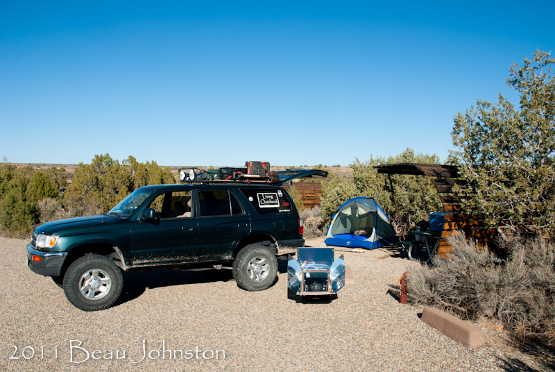
We found the campground to be a wonderful location for stargazing. Although the weather was turning cold, we opted to setup the tent without the rainfly so that we could bundle up in sleeping bags and enjoy the stars moving overhead.
More information on our trip and visit to Hovenweep can be found on our blog by clicking here.
Notes About Our Visit:
We arrived at the Hovenweep visitor center about midday and quickly set off to walk the 2-mile Square Tower Group Trail which leads from the visitor center out to and around the canyon. We took the recommended 1-1/2 hour time to explore and take photos and found it to be more than enough for a quick walk. After we setup camp I returned to the Hovenweep Castle Tower area to take some sunset photos.
The next morning we woke up, picked up camp, and headed off to the three outlying cliff ruins. We used the area map provided by the visitor center to make our way to the other ruins. Access to the ruins outside the main area is over dirt roads, which in spots were fairly rocky but not bad. We really enjoyed the Cutthroat Castle and Holly ruin and felt the drive and hike were worth it. During our hikes to these outlying ruins we never came across another person, something we really enjoyed.
Camping:
To make things easy for us we chose to camp at the Hovenweep camp ground which is about 1/3 of a mile from the visitor center. Access was easy and there were several RV and tent spots available as it was the off-season. The covered picnic table was nice and allowed us a place to get out from under the sun. The cost was $10/night, and they do not offer discounts for the Interagency Access Pass
We found the campground to be a wonderful location for stargazing. Although the weather was turning cold, we opted to setup the tent without the rainfly so that we could bundle up in sleeping bags and enjoy the stars moving overhead.
More information on our trip and visit to Hovenweep can be found on our blog by clicking here.
Dec 20, 2011 | 11:10 AM
#11
Thread Starter
Registered User
Joined: Aug 2006
Posts: 375
Likes: 0
From: The Big Wonderful
Lowry Pueblo
Thanks guys! It was a fun trip. I am about half way through the trip report with this post.
Lowry Pueblo
Location:
37�35'5.78"N 108�55'11.52"W

Hour and Fees:
Open during daylight hours
Free admission

Site Information:
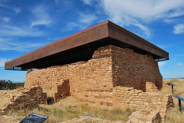
Part of the Canyons of the Ancients National Monument, Lowry Pueblo lies 27 miles north west of Cortez, Colorado and is home to a large Puebloan ruin. A paved trail leads from the parking area around the Great House. A portion of the pueblo is covered by a large roof to protect the excavated kiva. A small door on the south-east corner of the structure allows visitors to enter the structure and gaze into the kiva.
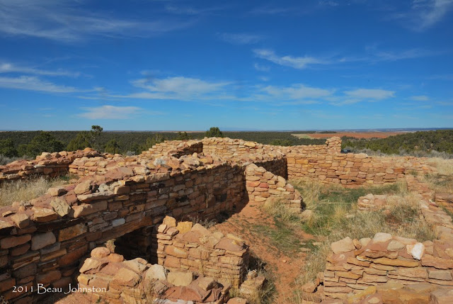
A second paved trail leads to the pueblo's Great Kiva, approximately 100 yards away. The kiva measures roughly 35-40ft in diameter and 7ft deep. The construction is was unusual when compared to the other kivas we visited on the trip. Two parallel structures within the kiva are said to represent the summer and winter people.

More information on our trip and visit to Lowry Pueblo can be found on our blog by clicking here.
Lowry Pueblo
Location:
37�35'5.78"N 108�55'11.52"W
Hour and Fees:
Open during daylight hours
Free admission
Site Information:
Part of the Canyons of the Ancients National Monument, Lowry Pueblo lies 27 miles north west of Cortez, Colorado and is home to a large Puebloan ruin. A paved trail leads from the parking area around the Great House. A portion of the pueblo is covered by a large roof to protect the excavated kiva. A small door on the south-east corner of the structure allows visitors to enter the structure and gaze into the kiva.
A second paved trail leads to the pueblo's Great Kiva, approximately 100 yards away. The kiva measures roughly 35-40ft in diameter and 7ft deep. The construction is was unusual when compared to the other kivas we visited on the trip. Two parallel structures within the kiva are said to represent the summer and winter people.
More information on our trip and visit to Lowry Pueblo can be found on our blog by clicking here.

Thread
Thread Starter
Forum
Replies
Last Post
IntoTheVoid
Trip-Trail Reports & Photos
41
Oct 24, 2015 04:54 PM
Odin
86-95 Trucks & 4Runners
3
Sep 26, 2015 06:56 PM


